
Free PDF preview of the Nigeria State Map Template (Cannot be edited)
PowerPoint (PPTX) download of the Nigeria State Map Template (Can be edited)
Document Purpose
The Nigeria State Map Template provides a fully customizable Nigerian States map that can copied into PowerPoint presentations and word documents. Each State on the map is labeled and can be relabeled according to requirements. Each State can easily be colored to highlight that State or a group of States and the map can also be resized.
The Nigerian States Map Template is ideally used in presentations where a distinction needs to be made between State or regions within Nigeria – e.g. a Sales presentation, a Nigerian development project or as a graphical illustration of a company’s foot-print in Nigeria
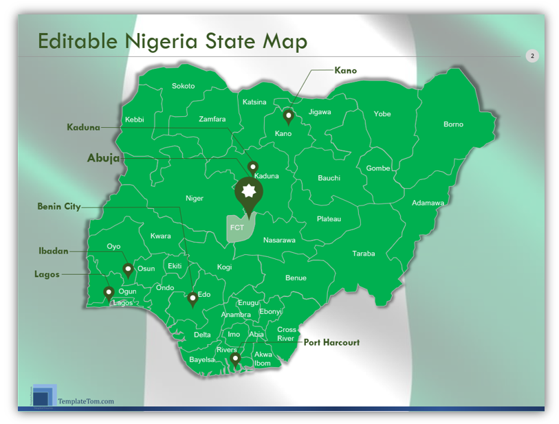
Document Contents
- Green color scheme Nigeria map on a Nigerian Flag background, with labeled States, markers for the 5 largest cities and the capital city
- Grey and Pink color scheme Nigeria map, with labeled States, markers for the 5 largest cities and the capital city
- Teal Color scheme Nigeria Map, with Colored Legend – highlighting four States and their most populous cities.
- White and Pink color scheme Nigeria map, with labeled States, markers for the 5 largest cities and the capital city
- Plain unlabeled Nigeria map, with Zoom on the Federal Capital Territory and the County’s Capital
Template Download
| Template | Description | Price | Action | Verification |
|---|---|---|---|---|
| Standard Option | Purchase the fully editable Nigeria States Map template in PowerPoint (pptx) format for both 16:9 (widescreen) and 4:3 (Standard) sizes | $3.50 |